Scope of Work:
GPR survey execution for mapping underground utilities and suspected locations of leakages in buried pipes upto 3 m depth to create database and for repair and maintenance purpose
Location:
Chennai, Tamil Nadu India.
Client:
Tamil Nadu Water Investment Company (TWIC)
Equipment:
GSSI SIR-3000 equipped 400 MHz antenna
Challenges:
Large number of junctions, heavy traffic, executed at night time
Summary:
The GPR survey has been carried out at T.Nagar area of Chennai smart City in the month
January. In total, 18 roads along with 207 number of junctions have been surveyed constituting total of 14 km to cover the
major parts and streets of the T-nagar area. The scope of work included the mapping of
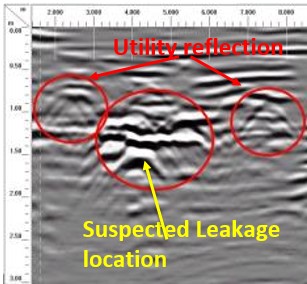
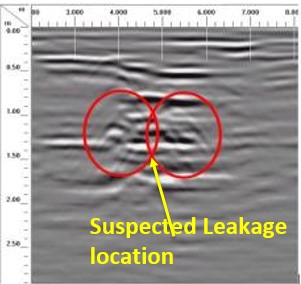
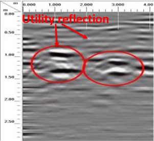
possible underground utilities viz. cables, water lines, gas lines, sewer line etc upto the depth of around 2-3 m using non-destructive Ground
Penetrating Radar technology. The purpose of the project is to develop a plan of underground
assets for the maintenance and planing of new infrastructure installation. Considering the
client's requirements and the expected depth of the utilities, the area has been surveyed using
400 MHz center frequency antenna mounted with SIR 3000 GPR system to cover the depth
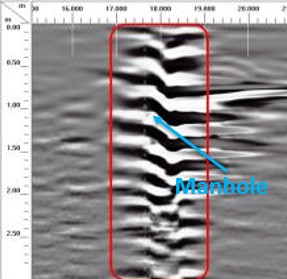
upto 2-3 m with fair resolution. Surface and buried manholes are also marked in the drawing. Suspected leakage locations were also marked.
A plan view along with sectional views have been generated with marked idenfied utilities. the located utilites were differentiated as metallic and non-metallic and classified as per ASCE standards.